

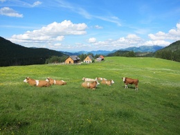
Ebenforstalm (via Reichraming)


- culturally interesting
Interactive elevation profile
Create PDF
Tour-Details
Starting place: 4462 Reichraming
Destination: 4462 Reichraming
duration: 4h 4m
length: 11,8 km
Altitude difference (uphill): 719m
Altitude difference (downhill): 5m
Lowest point: 390m
Highest point: 1.107m
difficulty: difficult
condition: very difficult
panoramic view: Dreamtour
Paths covering:
Asphalt, Path / trail, Gravel
powered by TOURDATA
Short description:
Hike in the Nationalpark Kalkalpen to the Ebenforstalm
Hike in the Nationalpark Kalkalpen to the Ebenforstalm
Quality of experience: *****
Recommended season:
- May
- June
- July
- August
- September
- October
Properties:
- Round trip
- Scenic
- Refreshment stops available
- Cultural/historical value
- Geological highlights
- Botanical highlights
- Faunistic highlights
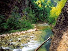
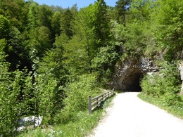
The hike leads from the barrier at Anzenbach along the Hintergebirgsradweg and then through the Wilden Graben to the Ebenforstalm.
Trail number: 472
Directions:
From the barrier the hiking trail leads flat parallel to the Hintergebirgsradweg along the Große Bach and then through the Wilden Graben up to the Ebenforstalm.
A further variant is the Begsteiger trail near the Klaushütte.
Tip:
Theme trail Wollgras, Alm und Wasserschwinde at the Ebenforstalm
Starting point: Reichraming/barriers in the Anzenbach
Destination: Reichraming/Ebenforstalm
further information:
- Board possible
Accessibility / arrival
Public Transit
The Ennstalbahn runs between Linz and Weißenbach-St. Gallen.
Parking
Reichraming/parking at Anzenbachschranken
Getting there
From Salzburg/Linz: A1 motorway exit Enns-Steyr > B115 into the Enns Valley
From Vienna: A1 motorway exit Haag > B42 > B122 > B115 into the Enns Valley
From Passau: A8 Passau > Wels > A1 motorway exit Enns-Steyr > B115 into the Enns Valley
From Graz: A9 Pyhrnautobahn > motorway exit Klaus > Grünburg > into the Ennstal Valley
Public Transit
The Ennstalbahn runs between Linz and Weißenbach-St. Gallen.
Details at www.ooevv.at
Railway Stations are located in Steyr, Garsten, Lahrndorf, Dürnbach, Ternberg, Trattenbach, Losenstein, Reichraming, Großraming, Gaflenz, Weyer, Küpfern, Kastenreith, Kleinreifling and Weißenbach-St. Gallen.
Parking
Reichraming/parking at Anzenbachschranken
Most economical season
- Spring
- Summer
- Autumn
Please get in touch for more information.
Stadtplatz 27
4400 Steyr
Phone +43 7252 53229 - 0
E-Mail info@steyr-nationalpark.at
Web www.steyr-nationalpark.at/
https://www.steyr-nationalpark.at/
Interactive elevation profile
Create PDF
Tour-Details
Starting place: 4462 Reichraming
Destination: 4462 Reichraming
duration: 4h 4m
length: 11,8 km
Altitude difference (uphill): 719m
Altitude difference (downhill): 5m
Lowest point: 390m
Highest point: 1.107m
difficulty: difficult
condition: very difficult
panoramic view: Dreamtour
Paths covering:
Asphalt, Path / trail, Gravel
powered by TOURDATA