

Lindaumauer from Gaflenz via Hochramskogel


Interactive elevation profile
Create PDF
Tour-Details
Starting place: 4443 Maria Neustift
Destination: 4443 Maria Neustift
duration: 1h 39m
length: 3,5 km
Altitude difference (uphill): 272m
Altitude difference (downhill): 272m
Lowest point: 825m
Highest point: 1.097m
difficulty: easy
condition: easy
panoramic view: Dreamtour
Paths covering:
Asphalt, Path / trail, Gravel, Hiking trail, Other
powered by TOURDATA
Short description:
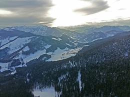
Summit circular trail starting from the snack station Hochramskogel with magnificent views over the Danube valley to the Mühlviertel, from the Tote Gebirge to the Haller Mauern and the Sengsengebirge.
Summit circular trail starting from the snack station Hochramskogel with magnificent views over the Danube valley to the Mühlviertel, from the Tote Gebirge to the Haller Mauern and the Sengsengebirge.
Quality of experience: ***
Recommended season:
- January
- February
- March
- November
- December
Properties:
- Round trip
- Scenic
- Summit route
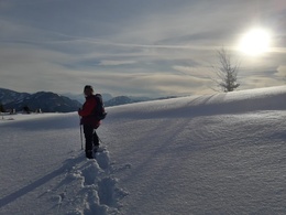
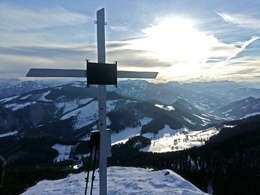
From the Jausenstation Hochramskogel you walk along the gravel road, across a meadow and through the forest to a saddle where the hiking trail from the Platten joins. Turn left on the narrowing trail under the southern flank of the Lindau wall and the path leads up to the summit cross.
Hiking trail: E32 or Variatne E04 from the Platten
Directions:
From the Hochramskogel snack station we follow the ascending gravel road for about 300 meters. Then the trail branches off to the left and leads us, becoming steeper, across a meadow. After a short steep section through the forest we reach a saddle where the hiking trail from the Platten joins. Turn left on the narrowing trail under the southern flank of the Lindau wall and left up to the summit cross.
Tip:
Pay a visit to the rock cave located just above the trail (bring a flashlight)!
Starting point: Gaflenz/Jausenstation Hochramskogel
Destination: Lindaumauer
Accessibility / arrival
Public Transit
The Ennstalbahn runs between Linz and Weißenbach-St. Gallen.
Parking
Gaflenz/Jausenstation Hochramskogel
Getting there
From Salzburg/Linz: A1 motorway exit Enns-Steyr > B115 into the Enns Valley
From Vienna: A1 motorway exit Haag > B42 > B122 > B115 into the Enns Valley
From Passau: A8 Passau > Wels > A1 motorway exit Enns-Steyr > B115 into the Enns Valley
From Graz: A9 Pyhrnautobahn > motorway exit Klaus > Grünburg > into the Ennstal Valley
Public Transit
The Ennstalbahn runs between Linz and Weißenbach-St. Gallen.
Details at www.ooevv.at
Railway Stations are located in Steyr, Garsten, Lahrndorf, Dürnbach, Ternberg, Trattenbach, Losenstein, Reichraming, Großraming, Gaflenz, Weyer, Küpfern, Kastenreith, Kleinreifling and Weißenbach-St. Gallen.
Parking
Gaflenz/Jausenstation Hochramskogel
Most economical season
- Spring
- Early winter
- Deep winter
Please get in touch for more information.
Stadtplatz 27
4400 Steyr
Phone +43 7252 53229 - 0
E-Mail info@steyr-nationalpark.at
Web www.steyr-nationalpark.at/
https://www.steyr-nationalpark.at/
Interactive elevation profile
Create PDF
Tour-Details
Starting place: 4443 Maria Neustift
Destination: 4443 Maria Neustift
duration: 1h 39m
length: 3,5 km
Altitude difference (uphill): 272m
Altitude difference (downhill): 272m
Lowest point: 825m
Highest point: 1.097m
difficulty: easy
condition: easy
panoramic view: Dreamtour
Paths covering:
Asphalt, Path / trail, Gravel, Hiking trail, Other
powered by TOURDATA