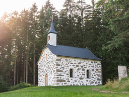
Liebenau - Kammerer-Kreuz

The Steinbloßkapelle Kammerer-Kreuz was once built in place of an image of a saint, which miraculously remained intact after being struck by lightning. It offers a marvellous view of the hills of the Mühlviertler Alm. The Kammerer cross is the closest point on the Johannesweg to Liebenau.
Paths covering:
further information:
- Experience of nature
All year round
Exit Linz, continue on Mühlkreis motorway/A7/E55
exit Mühlkreis motorway/A7/E55, continue on Mühlkreis motorway/A7/E55
turn left onto Mauthausener-Bundesstraße/B123
follow direction: Wartberg Weitersfelden Mauthausen Gutau
turn left onto Mauthausener-Bundesstraße/B123
turn right onto Bahnhofstraße
enter Pregarten, continue on Bahnhofstraße
in Pregarten continue on Stadtplatz
exit Pregarten, continue on Gutauer Straße
turn half left onto Pregartsdorf
continue
turn half right
keep right onto Marktplatz
turn right onto Marktplatz
turn half right
turn left
turn left turn
half turn left onto Hauptstraße
half turn left
half turn right onto Langfirling
turn right onto Weitersfelden
half turn left onto Nadelbach
half turn right onto Liebenau
- Suitable for groups
- Suitable for schools
- Suitable for kids (all ages)
- Suitable for teenagers
- Suitable for seniors
- Suitable for single travelers
- Suitable for families
- Suitable for friends
- Suitable for couples
- Suitable for children
- Spring
- Summer
- Autumn
Please get in touch for more information.
4252 Liebenau
Phone +43 7953 8111
Fax machine +43 7953 8111 - 30
E-Mail marktgemeinde@liebenau.at
Web www.liebenau.at


