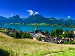
Malersteig circular route
Starting place: 5360 St. Wolfgang im Salzkammergut
Destination: 5360 St. Wolfgang im Salzkammergut
Start: St. Wolfgang market square.
Walk along the Florianigasse lane to the start of the Kalvarienberg path and contiue up to the Kalvarienberg church. Then on the Malersteig, which begins behind the church, over a ridge to the west and over stairs down to the Hupfmühle (Dittlbach waterfalls). Now a short distance back, then right on the road 150 downhill and left on a beautiful path back to the Kalvarienberg path and on the market square.
Walk along the Florianigasse lane to the start of the Kalvarienberg path and contiue up to the Kalvarienberg church. Then on the Malersteig, which begins behind the church, over a ridge to the west and over stairs down to the Hupfmühle (Dittlbach waterfalls). Now a short distance back, then right on the road 150 downhill and left on a beautiful path back to the Kalvarienberg path and on the market square.
Starting place: 5360 St. Wolfgang im Salzkammergut
Destination: 5360 St. Wolfgang im Salzkammergut
duration: 0h 58m
length: 2,9 km
Altitude difference (uphill): 118m
Altitude difference (downhill): 118m
Lowest point: 553m
Highest point: 637m
difficulty: easy
condition: easy
panoramic view: Some Views
Starting point: St. Wolfgang market square.
Destination: St. Wolfgang market square.
further information:
- Flatly
Most economical season
- Spring
- Summer
- Autumn
Please get in touch for more information.
Au 140
5360 St. Wolfgang im Salzkammergut
Phone +43 6138 8003
E-Mail info@wolfgangsee.at
Web wolfgangsee.salzkammergut.at
https://wolfgangsee.salzkammergut.at


