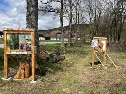
Forest nature trail Aigen-Schlägl
Starting place: 4160 Aigen-Schlägl
Destination: 4160 Aigen-Schlägl
The trail leads through a varied, harmonious forest and meadow landscape with beautiful wooded areas and views that open up to hikers.
The route is about 3 kilometres long. The walking time is 2 to 2.5 hours. Not suitable for wheelchairs and pushchairs. Well signposted.On 15 informative display boards, you can expand and deepen your knowledge of the forest habitat. You can also test your knowledge of the forest in a quiz. The Qr code that leads to the quiz can be scanned at the start board.
Tips and suggestions as well as further information about visiting the forest nature trail can be found on the homepage of the market town of Aigen-Schlägl.
you can hike the trail using navigation with the free outdooractive app.
Starting place: 4160 Aigen-Schlägl
Destination: 4160 Aigen-Schlägl
duration: 2h 0m
length: 3,2 km
Altitude difference (uphill): 83m
Altitude difference (downhill): 88m
Lowest point: 607m
Highest point: 695m
difficulty: very easy
condition: easy
panoramic view: Individual Views
Paths covering:
Street, Hiking trail
Starting point: Markplatz Aigen-Schlägl or Höhenstraße car park.
Destination: Markplatz Aigen-Schlägl or Höhenstraße car park.
further information:
- Flatly
- Possible accommodation
- Board possible
Details - hiking
- themed path
- educational path
- Suitable for seniors
- Suitable for families
- Suitable for friends
- Suitable for couples
- Suitable for children
- Spring
- Summer
- Autumn
- Early winter
Please get in touch for more information.
Dreisesselbergstraße 18
4160 Aigen-Schlägl
Phone +43 5 07263 - 200
E-Mail boehmerwald@muehlviertel.at
Web www.muehlviertel.at/
https://www.muehlviertel.at/


