Horse-drawn railway circular trail
Path number: Orange
Starting place: 4262 Leopoldschlag
Destination: 4262 Leopoldschlag
Marktplatz 1
4262 Leopoldschlag
4262 Leopoldschlag

The horse-drawn railway made a large loop in the municipality of Leopoldschlag in order to
comply with the prescribed 2.1% gradient. The so-called double loop (approx. 8 km long) was one of the most remarkable construction sections of the entire railway line in terms of engineering;
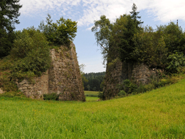
only exists in Leopoldschlag (due to the altitude, there are some particularly beautiful viewpoints on this circular route). The most impressive part of this section of the route was the large Edlbrucker Bridge with a span of 22.7 metres. The bridge was built in timber construction. In the area of the double loop, there were a total of 18 bridges and culverts, very high railway embankments and deep cuttings, which represented a masterpiece of engineering at the time. Many embankments and cuttings are still preserved in the forests. Two of the railway keeper's cottages located every 2-3 kilometres have also been preserved.
Path number: Orange
Starting place: 4262 Leopoldschlag
Destination: 4262 Leopoldschlag
duration: 2h 45m
length: 9,6 km
Altitude difference (uphill): 200m
Altitude difference (downhill): 200m
Lowest point: 618m
Highest point: 740m
difficulty: medium
condition: medium
panoramic view: No view
Paths covering:
Asphalt, Hiking trail, Other
Starting point: Hiking starting point Leopoldschlag (at the Wanderschuh, near Pension Hackermühle)
Destination: Hiking starting point Leopoldschlag (at the Wanderschuh, near Pension Hackermühle)
Details - hiking
- themed path
Most economical season
- Spring
- Summer
- Autumn
Please get in touch for more information.
Marktplatz 1
4262 Leopoldschlag
Phone +43 7949 8255
E-Mail anfrage@muehlviertel.at
Web www.leopoldschlag.ooe.gv.at/
Web www.muehlviertel-urlaub.at/wandern
https://www.leopoldschlag.ooe.gv.at/
https://www.muehlviertel-urlaub.at/wandern
https://www.muehlviertel-urlaub.at/wandern


