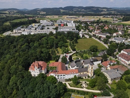
Hagenberg circular route
Path number: Nr. 49
Starting place: 4232 Hagenberg im Mühlkreis
Destination: 4232 Hagenberg im Mühlkreis
Kirchenplatz 5a
4232 Hagenberg im Mühlkreis
4232 Hagenberg im Mühlkreis

On this trail, you get to know the location of the village between the Visnitzbach nature experience and the Feldaisttal valley. The starting point is the war memorial in the centre of the village.
From the war memorial, you walk between the two snails through the castle park, in which there are centuries-old trees . The path now meanders down to the Visnitz, which you follow downhill to the Stöcklgrabener Güterweg.Continue walking directly eastwards, leave the Güterweg and walk through a small forest to the main road. Follow this road towards Hagenberg until the signpost leads into the Aisttal valley. Here we come to the Kumpfmühle mill.
On hot days, the Aisttal valley welcomes you with pleasant freshness and invites you to take a break. Immediately behind the Kumpfmühle mill, we follow a short, steep forest path out of the Aisttal valley.
On the right-hand side, the farm "Angerer" appears. The path leads past this farm to the sports centre, past the large pond and along the pond path back into the Visnitz valley.
Soon the loop closes and we walk on the familiar path back to the starting point.
Path number: Nr. 49
Starting place: 4232 Hagenberg im Mühlkreis
Destination: 4232 Hagenberg im Mühlkreis
duration: 1h 34m
length: 5,4 km
Altitude difference (uphill): 128m
Altitude difference (downhill): 122m
Lowest point: 376m
Highest point: 470m
difficulty: easy
condition: easy
panoramic view: No view
Paths covering:
Asphalt, Path / trail, Gravel, Street, Hiking trail, Other
Starting point: War memorial in the centre of Hagenberg
Destination: War memorial in the centre of Hagenberg
Most economical season
- Spring
- Summer
- Autumn
Please get in touch for more information.
Kirchenplatz 5a
4232 Hagenberg im Mühlkreis
Phone +43 7236 2318
E-Mail anfrage@muehlviertel.at
Web www.hagenberg.at/
Web www.muehlviertel-urlaub.at/wandern
https://www.hagenberg.at/
https://www.muehlviertel-urlaub.at/wandern
https://www.muehlviertel-urlaub.at/wandern


