Zum Schoberberg
Path number: 1
Starting place: 4240 Waldburg
Destination: 4240 Waldburg
Waldburg 8a
4240 Waldburg
4240 Waldburg

Discover the landscape around Waldburg. The starting point for all hiking trails is the village square in Waldburg.
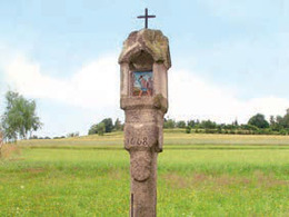
Waldburg - Güterweg Harruck - Weißes Kreuz (wayside shrine 15th century) - Mitterreith - Bauernhof "Haberl" southwards past - Gutenbrunnerweg - Brösl meyrberg - Gföhretwald - Brücke Gutenbrunnerbachl (municipal boundary Hirschbach i. M.) - Roamerhof - southwards past the airfield to Haghoferteich - northwards via Böhmerwaldstraße - uphill to Schoberberg - eastwards to the Lahrndorf goods road - southwards past Haiplhof (pond) along the field path to Kienmayrweg uphill to Mitterreith - Siemandl Bühel - Waldburg. Path number: 1
Starting place: 4240 Waldburg
Destination: 4240 Waldburg
duration: 2h 3m
length: 7,0 km
Altitude difference (uphill): 174m
Altitude difference (downhill): 174m
Lowest point: 659m
Highest point: 735m
difficulty: easy
condition: easy
panoramic view: Individual Views
Paths covering:
Asphalt, Hiking trail, Other
Starting point: Town square
Destination: Town square
further information:
- Flatly
Most economical season
- Spring
- Summer
- Autumn
Please get in touch for more information.
Waldburg 8a
4240 Waldburg
Phone +43 7942 8300 - 0
E-Mail gemeinde@waldburg.ooe.gv.at
Web www.waldburg.at/
Web www.muehlviertel-urlaub.at/wandern
https://www.waldburg.at/
https://www.muehlviertel-urlaub.at/wandern
https://www.muehlviertel-urlaub.at/wandern


