K33 Luegweg
Path number: K33
Starting place: 4292 Kefermarkt
Destination: 4292 Kefermarkt
information: Bitte beachten sie den Hinweis
The hiking trail leads past the church and the cemetery in the direction of Gutau.
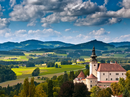
After a wayside shrine on the right, we walk left through the refreshing deciduous forests to the Tobelbach stream. We turn left and walk uphill towards Elz. Before the wayside shrine, we continue to the right along the forest and turn left before the "Linden" estate into the access road to the Kroneder farm. From there, we walk downhill to the right through the forest in the direction of "Vogeltenn". We enjoy the view of Weinberg Castle and the gentle Mühlviertel hills.You have well and truly earned a stop at the nearby Weinberg Castle Brewery or one of the local inns.
Path number: K33
Starting place: 4292 Kefermarkt
Destination: 4292 Kefermarkt
duration: 1h 33m
length: 5,0 km
Altitude difference (uphill): 164m
Altitude difference (downhill): 157m
Lowest point: 501m
Highest point: 646m
difficulty: easy
condition: easy
panoramic view: Individual Views
Paths covering:
Asphalt, Path / trail, Other
Starting point: Kefermarkt marketplace
Destination: Kefermarkt marketplace
Most economical season
- Spring
- Summer
- Autumn
Please get in touch for more information.
Oberer Markt 15
4292 Kefermarkt
Phone +43 7947 5910 - 0
E-Mail gemeinde@kefermarkt.ooe.gv.at
Web www.kefermarkt.ooe.gv.at/
Web www.muehlviertel-urlaub.at/wandern
https://www.kefermarkt.ooe.gv.at/
https://www.muehlviertel-urlaub.at/wandern
https://www.muehlviertel-urlaub.at/wandern


