K34 Altmühlweg
Path number: K34
Starting place: 4292 Kefermarkt
Destination: 4292 Kefermarkt
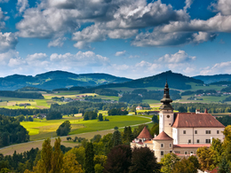
Round tour past the church and castle to the village of Elz and through forests and meadows back to Kefermarkt.
We set off uphill from the market square in Kefermarkt, passing the Gothic church and Weinberg Castle. We continue uphill through a forest until we come to a small road. We follow this road for a while, enter the forest again and reach the small village of Elz. From now on, the route goes downhill and reaches the former Altmühle sawmill. After a short stretch along the Gutau district road, the route climbs gently uphill again and, when the weather is fine, we have a great view of the mountains from the top. We now head downhill again on country lanes and forest paths, following the Flanitz stream to the town centre. A few more steps along the road and we are back at the starting point. Path number: K34
Starting place: 4292 Kefermarkt
Destination: 4292 Kefermarkt
duration: 3h 27m
length: 11,1 km
Altitude difference (uphill): 351m
Altitude difference (downhill): 352m
Lowest point: 503m
Highest point: 717m
difficulty: medium
condition: medium
panoramic view: Some Views
Paths covering:
Asphalt, Hiking trail, Other
Starting point: Kefermarkt marketplace
Destination: Kefermarkt marketplace
further information:
- Flatly
Most economical season
- Spring
- Summer
- Autumn
Please get in touch for more information.
Oberer Markt 15
4292 Kefermarkt
Phone +43 7947 5910 - 0
E-Mail gemeinde@kefermarkt.ooe.gv.at
Web www.kefermarkt.ooe.gv.at/
Web www.muehlviertel-urlaub.at/wandern
https://www.kefermarkt.ooe.gv.at/
https://www.muehlviertel-urlaub.at/wandern
https://www.muehlviertel-urlaub.at/wandern


