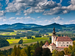
K40 Neumarkter-Weg
Path number: K40
Starting place: 4292 Kefermarkt
Destination: 4292 Kefermarkt
We walk downhill from the starting point, cross the railway and keep left at the Kefermarkt outdoor pool. We leave the last housing estate and reach the Lest stream. We cross this and the path climbs uphill for a while until we reach a chapel. We pass through a forest and reach a few remote houses. We then turn left uphill back to Kefermarkt.
Here you have the opportunity to visit the village of Neumarkt in Mühlkreis and its restaurants. After the short uphill section, the trail now continues downhill with a view of Kefermarkt. We walk past a small viewing platform and continue back to the starting point. After reaching the first residential buildings, we return along the same hiking trail.
Path number: K40
Starting place: 4292 Kefermarkt
Destination: 4292 Kefermarkt
duration: 2h 37m
length: 8,4 km
Altitude difference (uphill): 269m
Altitude difference (downhill): 271m
Lowest point: 466m
Highest point: 674m
difficulty: easy
condition: easy
panoramic view: Individual Views
Paths covering:
Asphalt, Hiking trail, Other
Starting point: Kefermarkt marketplace
Destination: Kefermarkt marketplace
further information:
- Flatly
Most economical season
- Spring
- Summer
- Autumn
Please get in touch for more information.
Oberer Markt 15
4292 Kefermarkt
Phone +43 7947 5910 - 0
E-Mail gemeinde@kefermarkt.ooe.gv.at
Web www.kefermarkt.ooe.gv.at/
Web www.muehlviertel-urlaub.at/wandern
https://www.kefermarkt.ooe.gv.at/
https://www.muehlviertel-urlaub.at/wandern
https://www.muehlviertel-urlaub.at/wandern


