K30 Luchsbergrundweg
Path number: K30
Starting place: 4292 Kefermarkt
Destination: 4292 Kefermarkt
Short circular tour around the Luchsberg, starting from the Kefermarkt market square;
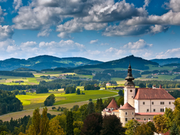
The church in Kefermarkt catches our eye right at the starting point. However, we turn right and walk off in the direction of Gutau. At the end of the village, we turn right, cross the Flanitz stream and walk along the stream for a short distance before it starts to climb in the forest. We soon reach a hill with two abandoned farms. From now on, the trail descends again, crosses the Flanitz again, briefly uphill and we have reached the local road again. We turn right and walk back to the starting point. Path number: K30
Starting place: 4292 Kefermarkt
Destination: 4292 Kefermarkt
duration: 1h 3m
length: 3,3 km
Altitude difference (uphill): 116m
Altitude difference (downhill): 115m
Lowest point: 495m
Highest point: 580m
difficulty: easy
condition: easy
panoramic view: Individual Views
Paths covering:
Asphalt, Gravel, Hiking trail, Other
Starting point: Kefermarkt marketplace
Destination: Kefermarkt marketplace
further information:
- Flatly
Most economical season
- Spring
- Summer
- Autumn
Please get in touch for more information.
Oberer Markt 15
4292 Kefermarkt
Phone +43 7947 5910 - 0
E-Mail gemeinde@kefermarkt.ooe.gv.at
Web www.kefermarkt.ooe.gv.at
Web www.muehlviertel-urlaub.at/wandern
https://www.kefermarkt.ooe.gv.at
https://www.muehlviertel-urlaub.at/wandern
https://www.muehlviertel-urlaub.at/wandern


