THE PATH OF SALT - Linz to Neumarkt im Mühlkreis
Path number: Etappe 5/1
Starting place: 4020 Linz
Destination: 4212 Neumarkt im Mühlkreis
Hauptplatz 19
4190 Bad Leonfelden
4190 Bad Leonfelden

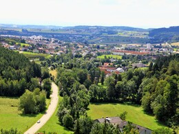
Historically interesting hike on partly lonely paths and asphalted side roads. Very well signposted, again and again you come across the easily recognizable route of the former railroad line.
The horse-drawn railroad hiking trail runs from Linz South Station (km 0) to St. Magdalena (km 5.8). Magdalena (km 5.8), on to Gallneukirchen (km 19.1), Neumarkt im Mühlkreis (km 32.7).
More information can be found on the website "The path of salt"
St. Magdalena: Gasthaus Auf der Wies, Gasthaus Lüftner, Oberwirt
Neumarkt im Mühlkreis: Gasthaus Ochsenwirt
UNTERNOON
Engerwitzdorf: Hotel Kreuzwirt
Gallneukirchen: Ferienwohnung Hassmann and Ferienwohnung Galli
POINTS OF INTEREST
St. Magdalena: Linzer Pferdebahnpromenade St. Magdalena
Path number: Etappe 5/1
Starting place: 4020 Linz
Destination: 4212 Neumarkt im Mühlkreis
duration: 9h 6m
length: 32,7 km
Altitude difference (uphill): 650m
Altitude difference (downhill): 375m
Lowest point: 253m
Highest point: 538m
difficulty: easy
condition: medium
panoramic view: Some Views
Paths covering:
Asphalt, Path / trail, unfixed, Hiking trail, Other
Starting point: Linz South Station
Destination: Neumarkt im Mühlkreis
further information:
- Possible accommodation
Details - hiking
- themed path
- Suitable for groups
- Suitable for seniors
- Suitable for single travelers
- Suitable for friends
- Suitable for couples
- Spring
- Summer
- Autumn
Please get in touch for more information.
Hauptplatz 19
4190 Bad Leonfelden
Phone +43 5 07263
E-Mail info@muehlviertel.at
Web www.muehlviertel.at
Web www.wegdessalzes.at/
https://www.muehlviertel.at
https://www.wegdessalzes.at/
https://www.wegdessalzes.at/


