Dorfrunde
Path number: 11
Starting place: 4362 Bad Kreuzen
Destination: 4362 Bad Kreuzen
Bad Kreuzen 20 a
4362 Bad Kreuzen
4362 Bad Kreuzen

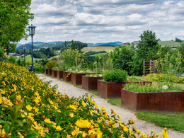
The village circuit takes you through the largest Kneipp garden in Austria, past 3 of our 4 hiking village businesses to Kreuzen Castle!
You are welcome to start our village tour at the market square or right outside the front door if you are staying overnight in one of our hiking village businesses, Gasthof Zur Zugbrücke, Schatzkammer Burg Kreuzen or in the Curhaus!From the hiking starting point, we hike through the Kneipp garden, around the Curhaus of the Sisters of Mary back to the village centre. Descending via the wild and romantic Gassl, the route leads through the Kühweid settlement, then cross the main road and walk uphill along a small forest path towards Kreuzen Castle.
Here we recommend walking through the castle and also making the ascent through the new "Healing Power of Water" exhibition in the castle tower to the top of the tower. The view from the keep is really worth it!
From Kreuzen Castle, we walk back up via Villa Böck Gasse, past the Atonement Cross and into the village centre.
This 5-kilometre loop is ideal for getting to know our village better on a short hike!
- All weather
- Suitable for groups
- Suitable for kids (all ages)
- Suitable for teenagers
- Suitable for seniors
- Suitable for single travelers
- Suitable for families
- Suitable for friends
- Suitable for couples
- Suitable for children
- Spring
- Summer
- Autumn
- Early winter
Please get in touch for more information.
Bad Kreuzen 20 a
4362 Bad Kreuzen
mobile +43 681 20583484
E-Mail info@gsundleben.att
Web gsundleben.at
https://gsundleben.at


