K35 Rundweg nach Freistadt
Path number: K35
Starting place: 4292 Kefermarkt
Destination: 4292 Kefermarkt
information: Beschilderung
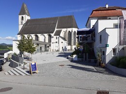
We set off uphill from the municipal office and pass the Kefermarkt parish church and Weinberg Castle.
Hike to Freistadt and back via Lasberg and Lest. Alternatively, you can break off the hike in Freistadt and take the train back. Ideal for hikers travelling by train.
Now we continue at a leisurely pace and next reach the village of Lasberg. The restaurants as well as sights such as the church and the market forge invite you to take a short breather. We now continue without heading towards Freistadt, often close to the road but surrounded by beautiful nature.In Freistadt we come directly to the Linzertor, turn left in front of it towards the brewery and join the parallel hiking trail FR10.
We hike to the edge of the town and reach the military cemetery.
We then continue parallel to the horse-drawn railway path to Lest. There we leave the horse-drawn railway, turn left, cross the main road and after 200m we turn left again and now walk parallel to the K39 back to Kefermarkt.
Alternatively, you can end the hike in Freistadt and travel back by public transport.
Refreshment stops along the hiking route:
- Gastronomy in Lasberg (e.g. Gasthaus Hofer directly on the hiking route)
- Gastronomy in Freistadt (e.g. Braugasthof Freistadt). Braugasthof Freistadt directly on the hiking route)
- Gasthaus Mader in Lest (directly on the hiking route)
- Gastronomy in the village:
- Restaurant Krah
- Schlossbrauerei Weinberg
- Cafe Stöckl
Path number: K35
Starting place: 4292 Kefermarkt
Destination: 4292 Kefermarkt
duration: 6h 31m
length: 23,3 km
Altitude difference (uphill): 423m
Altitude difference (downhill): 423m
Lowest point: 466m
Highest point: 669m
difficulty: medium
condition: medium
panoramic view: Some Views
Paths covering:
Asphalt, Path / trail, Hiking trail, Other
Starting point: Kefermarkt municipal office
Destination: Kefermarkt municipal office
further information:
- Flatly
- Experience of nature
Most economical season
- Spring
- Summer
- Autumn
Please get in touch for more information.
Oberer Markt 15
4292 Kefermarkt
Phone +43 7947 5910 - 0
E-Mail gemeinde@kefermarkt.ooe.gv.at
Web www.kefermarkt.ooe.gv.at
Web www.muehlviertel-urlaub.at/wandern
https://www.kefermarkt.ooe.gv.at
https://www.muehlviertel-urlaub.at/wandern
https://www.muehlviertel-urlaub.at/wandern


