Circular hike from Innerschwand to the lookout tower Kulmspitz
Path number: verschiedene Nummern
Starting place: 5310 Innerschwand am Mondsee
Destination: 5310 Innerschwand am Mondsee


Flatly
Dr. Franz Müller Str. 3
5310 Innerschwand am Mondsee
5310 Innerschwand am Mondsee

Beautiful but challenging circular hike through the municipality of Innerschwand to the Kulmspitz with its new lookout-tower.
After the start the path leads to the village centre of Loibichl, past the homecomer church. Always on traffic-poor freight roads, under the west highway A1 through we reach in the district Anzenberg a forest way. From there it always goes uphill to the highest point of the hike, the Kulmspitz.
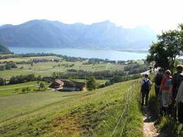
Strengthened with a summit snack we follow the hiking trail downhill. Don't forget to make a 30m long detour to the left about 200m below the summit - here a sensational panorama opens up to you at the edge of the forest.
The descent takes place on forest paths and partly on asphalted goods paths, until we reach already known terrain near Anzenberg. We follow the already known path back to the starting point at the bathing facility.
Tip: Don't forget your swimsuit so that you can end the day with a jump into the Mondsee.
Path number: verschiedene Nummern
Starting place: 5310 Innerschwand am Mondsee
Destination: 5310 Innerschwand am Mondsee
duration: 4h 21m
length: 11,5 km
Altitude difference (uphill): 690m
Altitude difference (downhill): 538m
Lowest point: 482m
Highest point: 1.065m
difficulty: medium
condition: difficult
panoramic view: Great panorama
Paths covering:
Asphalt, Hiking trail
Starting point: Public beach Innerschwand
Destination: Public beach Innerschwand
further information:
- Flatly


Accessibility / arrival
Start and end of the tour is at the beach in Innerschwand, approx. 6 km in the direction to Unterach am Attersee.
In the summer months (1st of May and 30th of September) EUR 3.00 per car.
- Suitable for teenagers
- Suitable for single travelers
- Suitable for friends
- Suitable for couples
- Spring
- Summer
- Autumn
Please get in touch for more information.
")
Dr. Franz Müller Str. 3
5310 Innerschwand am Mondsee
Phone +43 6232 2265
E-Mail info@mondsee.at
Web mondsee.salzkammergut.at/
https://mondsee.salzkammergut.at/
")
")
")
")