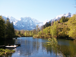
Path to the lakes "Ödseen"
Leisurely half-day hike on easy hiking trails
From there we follow path no. 404 on foot in the direction of Steyrling to the next fork in the path: straight ahead we go up towards the Ring; the promising resting place at the Herrentisch is just below this saddle, over which one arrives in the Steyrlingtal. However, we follow the board to the Ödseen to the left.
On the wide forest path we soon come to the large Ödsee in gentle ups and downs, while the path to the Kleiner Ödsee turns left beforehand. From the hunting lodge above the northern bay of the Großer Ödsee we keep to the left on a forest road for a short while along the bank and then hike through a forest valley into the valley of the Straneggbach. On the access road we march to the left for the last two kilometers up to the Almtaler Haus.
If you want to make your children particularly happy, attach an expedition to the desert-like debris cirque of the Hetzau or the Röll: for the little ones there are the largest sandpits in the country and for those who have a view of the 1,300 m high Schermberg -North Face, one of the mightiest wall crashes in the Alps. On its west side, at the end of the last Ice Age, around 15,000 years ago, a gigantic landslide occurred: The debris thundered more than 12 km out through the valley and also dammed the Almsee. To the south of it, under the bizarre Hetzaukögel and the 2,270 m high Rotgschirr, the glaciers have carved out the rocky gorge In der Röll - its name comes from the rolling of the rubble that fills the entire valley. The Kasberg should be mentioned in the same breath as Grünau. Summer or winter: it is always worth a trip. Take the high road and then march to the top to enjoy the wonderful view. Hut fun on the way is included.
Paths covering:
further information:
- Flatly
- Board possible
We recommend that you travel by public transport!
Bus-train information
By train: Arrival with the Almtalbahn 153 from Wels.
by bus: OÖVV bus line 533 Gmunden - Scharnstein - Grünau im Almtal - Almsee
Bus stop: Jagersimmerl
with the Traunstein taxi:
Route 60 from the railway station to the Almtalerhaus
Call the taxi office 1 hour in advance on 050-422 1691 or order on the otaxi app.
by bike: on the R 11 from Wels to Grünau im Almtal and the Almtalerhaus.
by car:
Motorway A1: Leave the Westautobahn A1 in Regau and follow the B145 to Scharnstein and Grünau im Almtal.
A9 motorway: Leave the A9 in Inzersdorf-Kirchdorf and follow the Austrian Romanikstraße to Scharnstein and Grünau im Almtal.
Please only use the parking spaces provided and be considerate of private property! Thank you for your fairness!
- Parking space: 50
- Free entry
- Suitable for groups
- Suitable for schools
- Suitable for single travelers
- Suitable for families
- Suitable for children
- Spring
- Summer
- Autumn
Suitable for wheelchairs: Not all of the legally stipulated ÖNORM are complied with. In principle, this object is suitable for wheelchairs and no assistance is necessary.
Im Dorf 17
4645 Grünau im Almtal
Phone +43 7616 8268
Fax machine +43 7616 8895
E-Mail almtal@traunsee-almtal.at
Web www.traunsee-almtal.at


