Hutterer Böden - Steyrsbergerreith - Wartegg - Hinterstoder
Path number: 11,31,1
Starting place: 4573 Hinterstoder
Destination: 4573 Hinterstoder
Hinterstoder 38
4573 Hinterstoder
4573 Hinterstoder

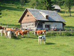
From the Hutterer Böden in Hinterstoder, hike to the Steyrsbergerreith and Wartegg, then return to the town centre of Hinterstoder.
From the bottom station of the cable car in Hinterstoder (also marked mountainbike trail) walk left towards Pension Edtbauernalm. Take a steep and small gravel road into the Rottal valley, pass the lower Edtbauernalm (not managed) to get to Steyrsbergerreith.Descent on trail nr. 31 direction Wartegg. Walk through the courtyard of the Wartegger Hof and continue on a steep meadow path and later along a tar road to Bäcker Ferdl and on to the country hotel Gressenbauer. At the country hotel Gressenbauer pass through the courtyard and take the hiking trail to your right direction Hinterstoder village.
Trail-Nr: 11, 31, 1
Path number: 11,31,1
Starting place: 4573 Hinterstoder
Destination: 4573 Hinterstoder
duration: 3h 30m
length: 10,5 km
Altitude difference (uphill): 42m
Lowest point: 588m
Highest point: 1.400m
difficulty: medium
condition: medium
panoramic view: Great panorama
Paths covering:
Asphalt, Gravel, Other
Starting point: Mountain station of the gondola lift up to the Hutterer Böden
Destination: Hinterstoder center
Accessibility / arrival
Starting point is the mountain gondola station.
Most economical season
- Summer
Please get in touch for more information.
Hinterstoder 38
4573 Hinterstoder
Phone +43 7564 5263
E-Mail hinterstoder@pyhrn-priel.net
Web www.urlaubsregion-pyhrn-priel.at
https://www.urlaubsregion-pyhrn-priel.at


