

Ameisenweg


- pets allowed
- All weather
- Suitable for families
- Suitable for pushchairs
- Suitable for kids (all ages)
- Flatly
- Possible accommodation
Interactive elevation profile
Create PDF
Tour-Details
Path number: Nr. 45
Starting place: 4273 Kaltenberg
Destination: 4273 Kaltenberg
duration: 0h 47m
length: 2,6 km
Altitude difference (uphill): 76m
Altitude difference (downhill): 76m
Lowest point: 790m
Highest point: 838m
difficulty: very easy
condition: very easy
panoramic view: Individual Views
Paths covering:
Hiking trail
powered by TOURDATA
Hiking trail in Kaltenberg in the Mühlviertel region
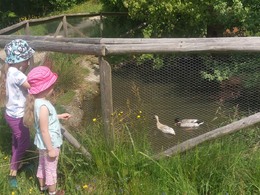
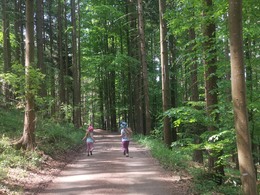
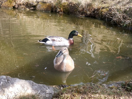
A leisurely hike that is also suitable for pushchairs: through the village square of Kaltenberg, you walk along the road downhill for a while before the path leads you past a small duck pond - a highlight for young and old alike. A small rest area with a bench and table next to the pond invites you to linger and watch the animals. The ant trail continues through the forest. Here you can feel the power of nature and recharge your batteries before heading back to Kaltenberg past the Augenbründl and the original chapel. Unless you make a detour to the highlight for children: a playground with a small motor skills park is located just 150 metres from the Ameisenweg (the playground is located behind the football pitch > simply walk along the pavement to the left of the road at the end of the forest path).
The trail
The Ameisenweg is a circular hiking trail. With a length of 2.6 km and an altitude difference of around 50 metres, it is an easy and short hiking trail in Upper Austria - ideal for families and with pushchairs.
Refreshments along the way
At the starting point in Kaltenberg, the traditional Kaltenbergerhof inn with its traditional cuisine invites you to stop for a bite to eat. In the cosy restaurant or in the guest garden, you will be well catered for.
Close to the village, around 500 m from the Ameisenweg and 900 m from the village centre, you will find the Langoth snack station, which will spoil you with a hearty snack, hearty meals and homemade pastries.
Naming
The Ameisenweg in Kaltenberg takes its name from the numerous anthills that can be observed on this hike.
Sights and highlights along the way
- St Mary's pilgrimage church in Kaltenberg
- Original chapel
- Augenbründl
- Stations of the Cross
- Playground with small motor skills park
- All weather
- Suitable for groups
- Suitable for kids (all ages)
- Suitable for pushchairs
- Pets allowed
- Suitable for seniors
- Suitable for single travelers
- Suitable for friends
- Suitable for couples
- Suitable for children
- Spring
- Summer
- Autumn
Suitable for wheelchairs: Not all of the legally stipulated ÖNORM are complied with. In principle, this object is suitable for wheelchairs and no assistance is necessary.
4273 Kaltenberg
Phone +43 7956 7305
E-Mail info@urkraftdorf.at
Web www.urkraftdorf.at
http://www.urkraftdorf.at
")
")
")
")
Interactive elevation profile
Create PDF
Tour-Details
Path number: Nr. 45
Starting place: 4273 Kaltenberg
Destination: 4273 Kaltenberg
duration: 0h 47m
length: 2,6 km
Altitude difference (uphill): 76m
Altitude difference (downhill): 76m
Lowest point: 790m
Highest point: 838m
difficulty: very easy
condition: very easy
panoramic view: Individual Views
Paths covering:
Hiking trail
powered by TOURDATA