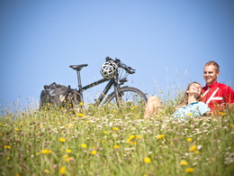
Färberrunde Nr. 912
Path number: 912
Starting place: 4293 Gutau
Destination: 4293 Gutau
St. Oswalderstraße 2
4293 Gutau
4293 Gutau

The start and finish of the circular cycle route is the beautiful market square in the centre of Gutau.
The route heads towards Pregarten, where you pass the e-bike charging station (in front of Gutau school) right at the start.
Now it's a leisurely 7 km ride through the beautiful countryside to Pregartsdorf, where you turn left towards Gmeinerhof. After 2 km and a very steep descent, you reach Reichenstein. After a possible visit to the Reichenstein ruins, you should take the opportunity to refresh yourself in the farm tavern opposite.
After a ride of approx. 10 km through the Aisttal valley, you have the option of making a detour to the Prandegg ruins at the "Riedlhammer". However, the Gutau cycle route continues along the Stampfenbach for approx. 5km, where you finally turn left towards Fürling. After a 1.5km climb, the Gasthaus Rampetsreiter offers another opportunity to fortify yourself for the remaining 10km.
From here, a short climb leads to the junction where you have to turn left and head back towards Gutau. The remaining, more leisurely section leads past the beautifully renovated Tannbach Castle and through the Au to Gutau.
Once you reach the market square, the numerous guest gardens of our inns invite you to relax. Afterwards, you should not miss the opportunity to visit the dyer's museum or enjoy a relaxing walk along the ornithological trail!
For those who feel at home in Gutau and would like to stay longer, there are numerous cosy hostels available.
Accessibility / arrival
by car:
Linz motorway - A7 - to Unterweitersdorf - Pregarten - Selker - Gutau
by train:
Summerauerbahn to Pregarten station (6 km) or Kefermarkt (5 km) to Gutau
Most economical season
- Spring
- Summer
- Autumn
Please get in touch for more information.
St. Oswalderstraße 2
4293 Gutau
Phone +43 7946 6255
E-Mail gemeinde@gutau.ooe.gv.at
Web www.muehlviertel-urlaub.at/rad
http://www.muehlviertel-urlaub.at/rad


