

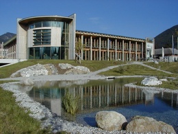
Jew's harp path


- Suitable for families
- culturally interesting
- Flatly
Interactive elevation profile
Create PDF
Tour-Details
Starting place: 4591 Molln
Destination: 4591 Molln
duration: 0h 46m
length: 3,1 km
Altitude difference (uphill): 27m
Altitude difference (downhill): 27m
Lowest point: 414m
Highest point: 442m
panoramic view: Individual Views
Paths covering:
Asphalt, Street
powered by TOURDATA
Short description:
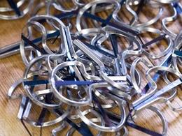
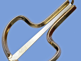
In the footsteps of the Jew's harp makers through the village
In the footsteps of the Jew's harp makers through the village
Recommended season:
- January
- February
- March
- April
- May
- June
- July
- August
- September
- October
- November
- December
Properties:
- Loop
- Refreshment stops available
- Family friendly
- Cultural/historical value
From the National Park Center walk in the direction of the parish church, then descend via Dolleschallberg to trail no. 6. The circular trail continues along Reibensteinstraße - Messererstraße - Sägewerkstraße - Sperrboden - Austraße - Waldeggstraße - Hafnerstraße - Alte-Post-Straße and back to the National Park Center.
Directions:
With this round you make yourself on the traces of the Jew's harp makers through the village. From the National Park Center, head towards the parish church, then down Dolleschallberg to trail no. 6. The circular trail continues along Reibensteinstraße - Messererstraße - Sägewerkstraße - Sperrboden (Wimmer Jew's Harp Show Factory) - Austraße - Waldeggstraße (Schwarz Jew's Harp and Harmonica Factory) - Hafnerstraße - Alte-Post-Straße and back to the National Park Center.
Tip:
In the Sperrboden you can look over the shoulder of the Jew's Harp makers at the Jew's Harp Show Wimmer.
In the Musikhaus Schwarz the jew's harp and harmonica making is shown.
Starting point: Molln/center of the village
Destination: Molln/center of the village
further information:
- Flatly
- Board possible

Cafe Konditorei Lebzelterei Illecker

Gasthof Steinbichler

Pizzeria Dolce Vita
Accessibility / arrival
Public Transit
The Steyrtal is served by bus lines 452 (Rohr-Bad Hall-Steinbach a. d. Steyr) and 433 (Steyr-Molln-Kirchdorf).
Parking
Molln/parking in the center of the village
Getting there
From the west: A1 exit Sattledt > via Kremsmünster > Bad Hall > Steinbach an der Steyr
From the east: A1 exit Haag > Steyr > B140 into the Steyr valley
From the north: A3 Passau > Wels > A9 exit Sattledt > Kremsmünster > Bad Hall > Steinbach
From the south: A9 exit Klaus > into the Steyr valley
Public Transit
The Steyrtal is served by bus lines 452 (Rohr-Bad Hall-Steinbach a. d. Steyr) and 433 (Steyr-Molln-Kirchdorf).
Details at www.ooevv.at
With the Steyrtal Museum Railway www.steyrtalbahn.at
Parking
Molln/parking in the center of the village
- Suitable for seniors
- Suitable for single travelers
- Suitable for friends
- Suitable for couples
- Suitable for children
- Spring
- Summer
- Autumn
- Early winter
- Deep winter
Please get in touch for more information.
Stadtplatz 27
4400 Steyr
Phone +43 7252 53229 - 0
E-Mail reichraming@steyr-nationalpark.at
Web www.steyr-nationalpark.at/
https://www.steyr-nationalpark.at/
")
")
")
")
")
")
Interactive elevation profile
Create PDF
Tour-Details
Starting place: 4591 Molln
Destination: 4591 Molln
duration: 0h 46m
length: 3,1 km
Altitude difference (uphill): 27m
Altitude difference (downhill): 27m
Lowest point: 414m
Highest point: 442m
panoramic view: Individual Views
Paths covering:
Asphalt, Street
powered by TOURDATA