

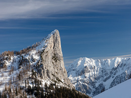
Stubwieswipfel ski tour (tour area Wurzeralm)


- Possible accommodation
Interactive elevation profile
Create PDF
Tour-Details
Path number: A3
Starting place: 4582 Spital am Pyhrn
Destination: 4582 Spital am Pyhrn
duration: 1h 28m
length: 5,8 km
Altitude difference (uphill): 960m
Lowest point: 1.358m
Highest point: 1.738m
difficulty: easy
condition: easy
panoramic view: Great panorama
Paths covering:
snow
powered by TOURDATA
The ski tour to the Stubwieswipfel is a very scenic tour with spectacular views deep and well suited for all skill levels!
From the Wurzeralm mountain station, drive down to the Linzerhaus and now cross the Teichlboden, straight to the Filzmoosalmen. From here it goes straight ahead through a sparse forest and on the forest road slightly uphill to just before the Stubwiesalmen. From the clearing at around 1,470 m, it now goes in a right-hand loop up the slope through a sparse larch forest, becoming ever steeper to a saddle. Now it goes back a bit flatter ... Starting point: Teichlboden
Destination: Stubwieswipfel
further information:
- Possible accommodation
- Board possible
Details - Ski
- Descent: difficulty: easy, 960 Metres of altitude
- Snowboard suitable
Accessibility / arrival
Exit the A9 Pyhrn autobahn in Spital am Pyhrn and follow the signs to the Wurzeralm valley station. From here you can take one of the ski tours to the Wurzeralm mountain station or use the Wurzeralm funicular.
Parking- Parking space: 2000
- Bus parking space: 100
Payment methods
Other payment methods
Cash payment
- Suitable for single travelers
- Suitable for friends
- Suitable for couples
- Early winter
- Deep winter
Please get in touch for more information.
Stiftsplatz 1
4582 Spital am Pyhrn
Phone +43 7563 249
Fax machine +43 7563 249 - 20
E-Mail spital@pyhrn-priel.net
Web www.urlaubsregion-pyhrn-priel.at
https://www.urlaubsregion-pyhrn-priel.at

")

Interactive elevation profile
Create PDF
Tour-Details
Path number: A3
Starting place: 4582 Spital am Pyhrn
Destination: 4582 Spital am Pyhrn
duration: 1h 28m
length: 5,8 km
Altitude difference (uphill): 960m
Lowest point: 1.358m
Highest point: 1.738m
difficulty: easy
condition: easy
panoramic view: Great panorama
Paths covering:
snow
powered by TOURDATA