Wildererweg Pyhrn-Priel - History

  • pets allowed
  • Suitable for families

 Interactive elevation profile

Download GPS data
Create PDF

Tour-Details

Starting place: 4575 Roßleithen
Destination: 4575 Roßleithen

duration: 2h 30m
length: 12,0 km
Altitude difference (uphill): 818m
Altitude difference (downhill): 77m

Lowest point: 669m
Highest point: 1.417m
difficulty: medium
condition: difficult
panoramic view: Great panorama

Paths covering:
Gravel, Hiking trail

powered by TOURDATA

information: Akutmeldung/Information
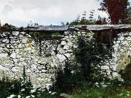
Poachers way history - the poacher Johann Fahrnberger trail is a journey through time to the scene Mayralm for connoisseurs of nature and history: 12 km hike to Mayralm and back

The trail starts steep and winds through a bright forest in the height. After a geschlägerten clearing followed by a less steep path through high, partly grassy coniferous forest and empties into a narrow passage through young forest.
An overgrown road runs at a slight incline to the edge of the national park.

After a small forest plateau, a narrow, steep path across the right steeply sloping hillside. It alternate clear exposed passages from shady forest crossings. In sweeping views of the mountains deep insights follow in primary forest landscapes.

Path and slope becomes steeper, it must be crossed trenches and Steinfeld, before you will be rewarded with a stunning view from Speikkogel 1112 meters above sea level.

The slope is crossed and now a short woody piece recirculation straight to the ridge and are on the other side the view of the flat bare ground free.

Links the trail continues down over a slope through a flat, wild overgrown wooded area with numerous anthills and huge fallen beeches for flat clearing Kainz floor.

On opposing forest beginning you can access to a rocky Holweg account, which leads straight through a clear forest landscape before it rises steeply after a slight left turn and abruptly opens a vast plateau - the Mayralm.

Fenced by low wooded hills crests, the plateau is like an arena in the center of the ruined Mayralm is as unreal ruin immediately before us.

About the meadow up on the ridge directly in the flight of the Mayralm found right near the forest of the so-called Hunter Stone (hunters Cross). It bears witness to the fierce battle, which took place on the Mayralm and perhaps is the cause of the mysterious atmosphere.

 
The Mayralm

Peace it is because that Mayralm. Nestled in a clear Almsenke. At the foot of Sengsen promontory. As a small paradise, a world unto itself. The location, the nature, the view - one understands immediately why one finds a hut right here. Or rather what is left of it. Today are from the former hunting, forestry, Holzknecht-, and forest ranger hut only the foundation walls. collapsed in to the stone walls, rotten that criss-cross on the meadow scattered ceiling beams of wood. Grasses are making their way through the wall cracks. Moss overgrown on the remains of former ceiling post. Still, it is here. Contemplative and lonely. With an idea of history.

It has meanwhile become quiet around the former mountain hut at the foot of the mountain pines overgrown Mayr Wipfels. Who would suspect that here - where today dozing cattle comfortably on taunassem grass - once occurred a great bloodshed? That the wide meadow stage of a dramatic spectacle was - a momentous shootout between hunters, poachers and policemen?

You know it. The walls that still draw the floor plan of Mayralm. They are stone witnesses of bygone times. Could they talk, they would tell you what has been here once happened in detail. When the first shot has been fired and has claimed its first victim. From poignant agonies and last breaths

BACKGROUND DETAILS

Starting point: diversion Salzatal
Destination: diversion Salzatal

Details - hiking
  • themed path
Accessibility / arrival

Motorway Rossleithen. After the warehouse turn left direction Windischgarsten Nord and drive over the railway tracks about 0,5 km along the road. After Billa supermarket turn left to the county nursing home, here turn left again and follow the left follow the road. Passing the entrance to the Villa Sonnwend turn the next possibility right.
After a few hundred meters of the trail starts to the left away towards Patzlberg.

Travelling by public transport
Route planner for independent travellers
  • Suitable for groups
  • Pets allowed
  • Suitable for teenagers
  • Suitable for single travelers
  • Suitable for friends
  • Suitable for couples
Most economical season
  • Spring
  • Summer
  • Autumn

Please get in touch for more information.


Wildererweg Pyhrn-Priel - History
Pyhrn-Priel Tourismus GmbH
Bahnhofstraße 2
4580 Windischgarsten

Phone +43 7562 5266
Fax machine +43 7562 5266 - 10
E-Mailinfo@pyhrn-priel.net
Webwww.wildererweg.at
http://www.wildererweg.at

We speak the following languages

German

 Interactive elevation profile

Download GPS data
Create PDF

Tour-Details

Starting place: 4575 Roßleithen
Destination: 4575 Roßleithen

duration: 2h 30m
length: 12,0 km
Altitude difference (uphill): 818m
Altitude difference (downhill): 77m

Lowest point: 669m
Highest point: 1.417m
difficulty: medium
condition: difficult
panoramic view: Great panorama

Paths covering:
Gravel, Hiking trail

powered by TOURDATA