BILDERRUNDWEG | Bewegungs-Arena INNVIERTEL
- All weather
- Suitable for families
- Suitable for pushchairs
- culturally interesting
- Flatly
Interactive elevation profile
Create PDF
Tour-Details
Starting place: 5241 Maria Schmolln
Destination: 5241 Maria Schmolln
duration: 0h 18m
length: 1,2 km
Altitude difference (uphill): 10m
Altitude difference (downhill): 11m
Lowest point: 542m
Highest point: 561m
difficulty: easy
condition: easy
panoramic view: Individual Views
Paths covering:
Asphalt, Gravel, Hiking trail
powered by TOURDATA
Old views - new impressions
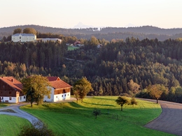
Discover the place of pilgrimage Maria Schmolln in eleven historical views on a 1.2 km long circular route. The photo panels show the development of the village from the year 1900, blue signposts offer orientation.
The recommended starting point is the pilgrim fountain next to the pilgrimage church Maria Schmolln (board no. 1). From there, follow the ground markings downhill for a short distance (board no. 2). After about 150 meters on the left, you can enjoy the view of the town center while sitting under the linden tree (sign no. 3). The path continues slightly uphill towards the old people's home (sign no. 4). With a view towards the church, follow the trail markings (board no. 5 and board no. 6) past the elementary school, keep to the right of the church, walk under the listed linden trees to the playground (board no. 7). There you cross the safety path (sign no. 8), turn left at the kindergarden (sign no. 9) and follow the path to the Hellstern bakery (sign no. 10) and the Zöpfl inn. Now turn left again in the direction of the church (sign no. 11 in front of the large birch tree).
Tip: Around Maria Schmolln you look through 5 oversized landscape frames at the beautiful pilgrimage site.
further information:
- Flatly
Details - hiking
- themed path
Relaxliege
- All weather
- Suitable for groups
- Suitable for schools
- Suitable for pushchairs
- Suitable for teenagers
- Suitable for seniors
- Suitable for single travelers
- Suitable for friends
- Suitable for couples
- Spring
- Summer
- Autumn
- Early winter
Suitable for wheelchairs: Not all of the legally stipulated ÖNORM are complied with. In principle, this object is suitable for wheelchairs and no assistance is necessary.
5241 Maria Schmolln
Phone +43 7743 2255 - 0
E-Mail gemeinde@maria-schmolln.ooe.gv.at
Web www.maria-schmolln.ooe.gv.at
http://www.maria-schmolln.ooe.gv.at
You can also visit us on
Visit us on Facebook BlogInteractive elevation profile
Create PDF
Tour-Details
Starting place: 5241 Maria Schmolln
Destination: 5241 Maria Schmolln
duration: 0h 18m
length: 1,2 km
Altitude difference (uphill): 10m
Altitude difference (downhill): 11m
Lowest point: 542m
Highest point: 561m
difficulty: easy
condition: easy
panoramic view: Individual Views
Paths covering:
Asphalt, Gravel, Hiking trail
powered by TOURDATA