Waldluftbadeweg St. Peter
Path number: Route mit roten Legenden
Starting place: 4240 Freistadt
Destination: 4240 Freistadt
Waaggasse 6
4240 Freistadt
4240 Freistadt

Forest air bathing in Freistadt
Freistadt lies in the northern part of the Freistadt Basin, which is part of the Central Mühlviertel highlands. The urban organism is bordered by a horseshoe-shaped chain of hills and closed off to the south by the Jaunitz. In between, the life-giving Feldaist flows from north to south. The landscape centre of Freistadt is the Dreißgerberg (739 m). The Trölsberg in the south forms a separate landscape area with the Zeißberge on the edge of the Freistadt basin.
If you start at the main square, walk northwards through the Böhmertor and the Böhmer Vorstadt along the meditation path: Kalvarienbergstraße, Sieben-Schmerzen-Weg, Kreuzstein, continue along Bockaubach into Bockau, Vogeltenn, St.Peter. Return via the Way of the Cross or continue through the forest to the Fuchsenhof and via Fr6 to the Pregartenteich and through the Linzer Tor to the main square.
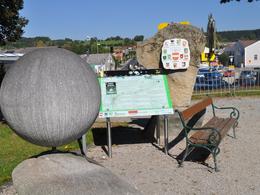
The Kreuzstein is a rock that was originally a cup stone. Shortly afterwards, between the cross stone and the forest, you come to a meadow with a lunar quality. This is a good place to work on spiritual issues. At this healing cult site, a Bronze Age moon sanctuary, shamanesses healed with the energies of the place and the herbs. The place where a medicinal plant grows has the same effect as the medicinal plant itself. After crossing the Bockaubach stream, you enter the Bockau forest area. The prehistoric energy of Freistadt's landscape organism is stored in this ancient forest and can still be felt. The resonance of watery atmospheres with people is intuition, feelings and relationships.
Before St Peter's you come across a meadow called Vogeltenn. Vogel comes from the root word Fackel, lat: facula, adh: facchela. Vogeltenn can then be interpreted as a fireplace. Vogeltenn fields are usually found on hills or mountains. As the dialect pronunciation of the plural form is never Vögel, but always Feigl, the word may also be based on the Latin "Vigil", the term for "night watch". Watches were kept at Vogeltenn places and signal fires were lit.
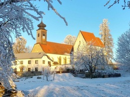
The late Gothic filial church of St. Peter stands around three kilometres west of Freistadt on a hill 700 metres above sea level and is clearly visible from afar. The Calvary Chapel is located next to the church. The church is based on a Romanesque predecessor building. Before that, there was a pre-Christian place of worship here. The open-air area has a sunny quality and is a good place to work on spiritual themes. There was a sun sanctuary and fire place with other places of worship on the east side of the enclosing wall.
Return via the Way of the Cross, which was built in 1842. It consists of monuments with 14 winter lime trees and a copper beech, which stretch along the meditation path between Freistadt and St.Peter. An alternative Fr6 trail leads via the Fuchsenhof, a late medieval castle complex that is now used as a farm. In 1997, an important silver treasure from 1270 was found nearby.
Waldluftbadeweg St.Peter - Waypoints
1. hiking stone
2. 7 pains path
3. cross stone
4. moon sanctuary
5th Bockaubach stream
6. forest devotion
7th Bockau
8th Vogeltenn
9th Church of St Peter
10. calvary chapel
11th Way of the Cross
12. 3-Höfe-Weg (alternative)
13. pregarten pond
This path is also partly possible as a snowshoe hiking trail (start from Bockau, from there it is a forest path, possible up to St. Peter's Church and down via the Way of the Cross)
For guided tours, please contact our qualified forest air bathing masters - you can find more information here.
Path number: Route mit roten Legenden
Starting place: 4240 Freistadt
Destination: 4240 Freistadt
duration: 2h 47m
length: 9,5 km
Altitude difference (uphill): 232m
Altitude difference (downhill): 229m
Lowest point: 548m
Highest point: 714m
difficulty: easy
condition: easy
panoramic view: Individual Views
Paths covering:
Hiking trail, Other
Starting point: Wanderstein Freistadt
Destination: Wanderstein Freistadt
further information:
- Flatly
Details - hiking
- themed path
- All weather
- Suitable for groups
- Suitable for schools
- Suitable for teenagers
- Suitable for seniors
- Suitable for single travelers
- Suitable for families
- Suitable for friends
- Suitable for couples
- Suitable for children
- Spring
- Summer
- Autumn
Please get in touch for more information.
Waaggasse 6
4240 Freistadt
Phone +43 5 07263 - 301
E-Mail badzell@muehlviertel.at
Web www.muehlviertel.at
Web www.muehlviertel-urlaub.at/wandern
https://www.muehlviertel.at
http://www.muehlviertel-urlaub.at/wandern
http://www.muehlviertel-urlaub.at/wandern


