

Waldluftbadeweg Jaunitz – St.Peter - Rainbach


- All weather
- Flatly
Interactive elevation profile
Create PDF
Tour-Details
Path number: Route mit blauen Legenden
Starting place: 4261 Rainbach im Mühlkreis
Destination: 4261 Rainbach im Mühlkreis
duration: 5h 46m
length: 20,5 km
Altitude difference (uphill): 395m
Altitude difference (downhill): 395m
Lowest point: 575m
Highest point: 714m
difficulty: easy
condition: easy
panoramic view: Individual Views
Paths covering:
Hiking trail, Other
powered by TOURDATA
roadblock: asfinag Tunnelbau Vierzehn
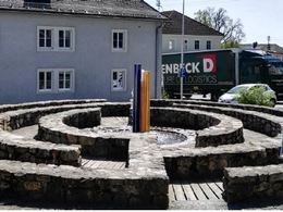
since 01.01.2024 Forest air bathing in Rainbach
Rainbach lies in the Mühlviertel highlands between the mountain ranges of the Bohemian Forest and Sternwald to the west and the Freiwald to the east. The north-south connection through the Bohemian Gate to Bohemia, which has been important since early history, runs through the municipality. It is also home to the Heidenstein, an ancient and important cult centre. The centre of the Rainbach plateau is the Birauberg to the north-west, a once very impressive moorland forest.
Forest air bathing trail Jaunitz - St.Peter - Feldaist
The hike starts from the Wanderstein at the labyrinth in the village and follows the R5 westwards to the confluence of the Rainbach and Jaunitz rivers. The trail follows the Jaunitz valley, past the Sonnmühle mill. We walk along the horse-drawn railway track between Gruberbühel and Unterschwandt through the Jaunitz valley. In this valley, the Jaunitz river exudes an almost geological atmosphere. You get the feeling that dinosaurs, sabre-toothed tigers or mammoths could turn the corner at any time.
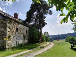
In Unterschwandt, we follow the turn-off to the left onto the Wa6 to St. Peter. The ascent is rewarded by the late Gothic church of St. Peter and the Calvary Chapel next to it, which stand around three kilometres west of Freistadt on a hill around 700 metres above sea level and are clearly visible from afar. The church is based on a Romanesque predecessor building, before which there was a pre-Christian place of worship with a sun sanctuary and fire place in the open area and other places of worship on the eastern side of the surrounding wall.
After St Peter's you come to a stone hill called Vogeltenn. Vogel comes from the root word Fackel, lat: facula, adh: facchela. Accordingly, Vogeltenn can be interpreted as a fireplace. Vogeltenn fields are usually found on hills or mountains. As the dialect pronunciation of the plural form is never Vögel, but always Feigl, the word may also be based on the Latin "Vigil", the term for "night watch". Watches were kept at Vogeltenn places and signal fires were lit.
We follow the water hiking trail through the Bockau to Vierzehn. On the way there, it is worth making a detour to the Dreißgerberg. After the village of Vierzehn, we descend to the Feldaist. Detour to the Neumühle mill (currently closed). Aist hike Dornmühle, Schwabenmühle, Dürnberg, Hintermühle and return to Rainbach.
Waldluftbadeweg Jaunitz - St.Peter - Waypoints
1. hiking stone
2. mouth of the Grottenbach in the Rainbach
3. mouth of the Rainbach into the Jaunitz
4. Jaunitz and Jaunitztal
5. St.Peter
6. calvary chapel
7. Vogeltenn
8th Bockau
9th Dreißgenberg
10. Feldaist and Neumühle
11th Kropfhammer
12. thorn mill
13th Schwabenmühle
14. Dürnberg
15. Hintermühle
ATTENTION: On this tour there was a route change at point 5 - St. Peter, which is correct online (GPS data) (the old route is still marked on the hiking map).
For guided tours, please contact our qualified forest air bathing instructors - you can find more information here.
Rainbach lies in the Mühlviertel highlands between the mountain ranges of the Bohemian Forest and Sternwald to the west and the Freiwald to the east. The north-south connection through the Bohemian Gate to Bohemia, which has been important since early history, runs through the municipality. It is also home to the Heidenstein, an ancient and important cult centre. The centre of the Rainbach plateau is the Birauberg to the north-west, a once very impressive moorland forest.
Forest air bathing trail Jaunitz - St.Peter - Feldaist
The hike starts from the Wanderstein at the labyrinth in the village and follows the R5 westwards to the confluence of the Rainbach and Jaunitz rivers. The trail follows the Jaunitz valley, past the Sonnmühle mill. We walk along the horse-drawn railway track between Gruberbühel and Unterschwandt through the Jaunitz valley. In this valley, the Jaunitz river exudes an almost geological atmosphere. You get the feeling that dinosaurs, sabre-toothed tigers or mammoths could turn the corner at any time.
In Unterschwandt, we follow the turn-off to the left onto the Wa6 to St. Peter. The ascent is rewarded by the late Gothic church of St. Peter and the Calvary Chapel next to it, which stand around three kilometres west of Freistadt on a hill around 700 metres above sea level and are clearly visible from afar. The church is based on a Romanesque predecessor building, before which there was a pre-Christian place of worship with a sun sanctuary and fire place in the open area and other places of worship on the eastern side of the surrounding wall.
After St Peter's you come to a stone hill called Vogeltenn. Vogel comes from the root word Fackel, lat: facula, adh: facchela. Accordingly, Vogeltenn can be interpreted as a fireplace. Vogeltenn fields are usually found on hills or mountains. As the dialect pronunciation of the plural form is never Vögel, but always Feigl, the word may also be based on the Latin "Vigil", the term for "night watch". Watches were kept at Vogeltenn places and signal fires were lit.
We follow the water hiking trail through the Bockau to Vierzehn. On the way there, it is worth making a detour to the Dreißgerberg. After the village of Vierzehn, we descend to the Feldaist. Detour to the Neumühle mill (currently closed). Aist hike Dornmühle, Schwabenmühle, Dürnberg, Hintermühle and return to Rainbach.
Waldluftbadeweg Jaunitz - St.Peter - Waypoints
1. hiking stone
2. mouth of the Grottenbach in the Rainbach
3. mouth of the Rainbach into the Jaunitz
4. Jaunitz and Jaunitztal
5. St.Peter
6. calvary chapel
7. Vogeltenn
8th Bockau
9th Dreißgenberg
10. Feldaist and Neumühle
11th Kropfhammer
12. thorn mill
13th Schwabenmühle
14. Dürnberg
15. Hintermühle
ATTENTION: On this tour there was a route change at point 5 - St. Peter, which is correct online (GPS data) (the old route is still marked on the hiking map).
For guided tours, please contact our qualified forest air bathing instructors - you can find more information here.
further information:
- Flatly
Details - hiking
- themed path
")
")


")
")

- All weather
- Suitable for groups
- Suitable for schools
- Suitable for teenagers
- Suitable for seniors
- Suitable for single travelers
- Suitable for friends
- Suitable for couples
- Spring
- Summer
- Autumn
- Early winter
Please get in touch for more information.
")
Prager Straße 5
4240 Freistadt
Phone +43 7949 6255
E-Mail freistadt@muehlviertel.at
Web www.waldluftbaden.at
http://www.waldluftbaden.at
Interactive elevation profile
Create PDF
Tour-Details
Path number: Route mit blauen Legenden
Starting place: 4261 Rainbach im Mühlkreis
Destination: 4261 Rainbach im Mühlkreis
duration: 5h 46m
length: 20,5 km
Altitude difference (uphill): 395m
Altitude difference (downhill): 395m
Lowest point: 575m
Highest point: 714m
difficulty: easy
condition: easy
panoramic view: Individual Views
Paths covering:
Hiking trail, Other
powered by TOURDATA