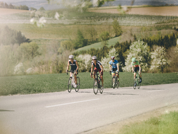
24h Cycling marathon route
Starting place: 4710 Grieskirchen
Destination: 4710 Grieskirchen
Easy racing bike tour. For all fitness levels. Mainly good road surfaces. Easy to ride. The starting point of the tour is accessible by public transport.
You will experience real bike marathon flair - as the name of the tour already reveals - on the 24-hour bike marathon route, an easy racing bike tour that is suitable for all fitness levels. You cycle from Grieskirchen on predominantly good road surfaces through the gentle hilly landscape of the Vitalwelt region, enjoy a wonderful view and master a total of 21.5 kilometers and about 170 meters of altitude before you arrive back in Grieskirchen at the end point of the tour. Starting place: 4710 Grieskirchen
Destination: 4710 Grieskirchen
duration: 0h 33m
length: 21,5 km
Altitude difference (uphill): 174m
Altitude difference (downhill): 174m
Lowest point: 308m
Highest point: 399m
difficulty: easy
condition: easy
panoramic view: Individual Views
Paths covering:
Street, Other
Starting point: Town square Grieskirchen
Destination: Town square Grieskirchen
further information:
- Flatly
- Possible accommodation
- Board possible
Most economical season
- Spring
- Summer
- Autumn
Please get in touch for more information.
Promenade 2
4710 Grieskirchen
Phone +43 7249 42071 - 0
E-Mail info@vitalwelt.at
Web www.vitalwelt.at
https://www.vitalwelt.at


