Stadtgeschichten - Streifzug durch Freistadt
Starting place: 4240 Freistadt
Destination: 4240 Freistadt
Hauptplatz 1
4240 Freistadt
4240 Freistadt

Every corner tells a piece of history. In 2020, Freistadt is officially a city
in its prime.
Discover our more than 800-year-old past on a walk through the town and experience your own personal Freistadt history.
where you can discover and explore the history and stories of our medieval brewing town. In the book itself you will find one of our town stories every month.
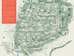
Waypoints:
1st Freiung
2. outer castle courtyard
3. Bohemian Gate
4. Heiligen-Geist-Gasse
5. old smithy and Scheibling tower
6. Salzgasse with "Reiha"
7. salt yard
8th Eisengasse
9th Zwinger
10. Linz Gate
A free guided city walk is also offered from May to September: Meeting point is every Friday at 7 pm in the outer castle courtyard.
(Duration: approx. 1 hour; no registration required!)
Starting place: 4240 Freistadt
Destination: 4240 Freistadt
duration: 1h 0m
length: 1,5 km
Altitude difference (uphill): 8m
Altitude difference (downhill): 9m
Lowest point: 552m
Highest point: 564m
difficulty: very easy
condition: very easy
panoramic view: No view
Paths covering:
Asphalt, Other
Starting point: Main square Freistadt
Destination: Main square Freistadt
further information:
- Flatly
Circular route on your own, therefore accessible daily
Rathaus, 1, Hauptplatz, Graben, Freistadt, Bezirk Freistadt, Oberösterreich, 4240, Österreich
Rathaus, 1, Hauptplatz, Graben, Freistadt, Bezirk Freistadt, Oberösterreich, 4240, Österreich
- All weather
- Spring
- Autumn
- Early winter
Suitable for wheelchairs: Not all of the legally stipulated ÖNORM are complied with. In principle, this object is suitable for wheelchairs and no assistance is necessary.
Hauptplatz 1
4240 Freistadt
Phone +43 7942 72506 - 61
E-Mail stadtmarketing@freistadt.ooe.gv.at
Web freistadt.city/
https://freistadt.city/


