110 Gutau round
Path number: 110
Starting place: 4293 Gutau
Destination: 4293 Gutau


St. Oswalderstraße 2
4293 Gutau
4293 Gutau

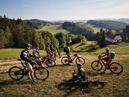
From the starting point at the Gutau Dyers' Museum you make your way past the market square towards Selker, after a few minutes you turn off onto a meadow path and cycle through a beautiful valley past the Klausmühle, peppered with a few short ascents and descents into the Waldaisttal.
After 3 kilometers on great forest paths, you now follow the road for a while to the ruins of Reichenstein Castle. It's a pleasant roll and this section is quickly over.That's a good thing, because now the Mühlviertel shows its teeth, with a steep climb past the ruins on a challenging forest path that shows who has enough energy in their calves.....or battery.
After pedaling uphill for around 350 m, you pass the Guttenbrunnerberg.
There is a great view from the rustic hut of the Mühlviertel Archery Club, which is conveniently located directly on the route.
The next 13 km are varied, with constantly changing types of paths and gradients, making the ride through the beautiful hilly landscape a mountain bike delight.
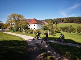
In Erdmannsdorf, you reach the highest point of the tour and are greeted by a great village store with a cozy seating area, where you can choose from a variety of refreshments and snacks to prepare you for the onward journey to Führling and the subsequent rapid descent into the Stampfenbach valley.
In the shady valley, you follow the course of the stream on the goods road for around 1.5 kilometers before turning right into the last uphill section. On a rather steep forest path, you fight your way towards the end of the loop.
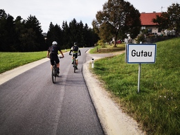
You can now enjoy a well-deserved rest in one of the inns in Gutau and recover from this rather demanding tour.
Around 48% of the route is on natural trails, while the remaining 52% is on paved paths and asphalt (26%).
Nature is always there for us. So it is only fair that we are there for nature too.
Please observe the fair play rules for mountain biking!
Path number: 110
Starting place: 4293 Gutau
Destination: 4293 Gutau
duration: 3h 28m
length: 38,3 km
Altitude difference (uphill): 1.090m
Altitude difference (downhill): 1.087m
Lowest point: 351m
Highest point: 755m
difficulty: medium
condition: difficult
panoramic view: Great panorama
Paths covering:
Asphalt, Path / trail, Gravel, Other
Starting point: Car park Fäbermuseum Gutau
Destination: Car park Fäbermuseum Gutau
")


")

")
")
")

")
")
")
Most economical season
- Spring
- Summer
- Autumn
Please get in touch for more information.
")
St. Oswalderstraße 2
4293 Gutau
Phone +43 7946 6255
E-Mail anfrage@muehlviertel.at
Web www.muehlviertel-urlaub.at/bike
http://www.muehlviertel-urlaub.at/bike