

45 Wolfgang Walking Trail


- pets allowed
- All weather
- Suitable for families
- culinary interesting
Interactive elevation profile
Create PDF
Tour-Details
Starting place: 4550 Kremsmünster
Destination: 4550 Kremsmünster
duration: 1h 31m
length: 5,5 km
Altitude difference (uphill): 90m
Altitude difference (downhill): 64m
Lowest point: 356m
Highest point: 408m
difficulty: easy
condition: medium
panoramic view: Great panorama
Paths covering:
Asphalt, Hiking trail
powered by TOURDATA
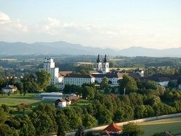
45 Wolfgang hiking trail
Kremsmünster Abbey car park - abbey area - Kirchberg church - Wolmersgraben - quarry - Wolfgang column - Roman path - Grubmühle - Kirchberg - origin - monastery - starting point
Walking time: 2 hours 30 minutes
Difference in altitude: approx. 70 meters
Difficulty: easy
Starting point: Abbey car park

")

")
")
")
")
")
")
")
")
")


")
")
")

")
")


")
")
")
")


- All weather
- Suitable for groups
- Suitable for schools
- Pets allowed
- Suitable for single travelers
- Suitable for families
- Spring
- Summer
- Autumn
Please get in touch for more information.
4550 Kremsmünster
Phone +43 7242 67722 - 22
Fax machine +43 7242 67722 - 4
E-Mail info@wels.at
Web www.wels.at/index.php?id=14260
Web www.kremsmuenster.at/Tourismus/Wand…
https://www.wels.at/index.php?id=14260
https://www.kremsmuenster.at/Tourismus/Wanderwege/Wolfgangweg
https://www.kremsmuenster.at/Tourismus/Wanderwege/Wolfgangweg
Interactive elevation profile
Create PDF
Tour-Details
Starting place: 4550 Kremsmünster
Destination: 4550 Kremsmünster
duration: 1h 31m
length: 5,5 km
Altitude difference (uphill): 90m
Altitude difference (downhill): 64m
Lowest point: 356m
Highest point: 408m
difficulty: easy
condition: medium
panoramic view: Great panorama
Paths covering:
Asphalt, Hiking trail
powered by TOURDATA