Pferdeeisenbahn Wanderweg - Etappe 2
Path number: Rainbach - Lest
Starting place: 4261 Rainbach im Mühlkreis
Destination: 4291 Kefermarkt
Lichtenauer Straße 11
4261 Rainbach im Mühlkreis
4261 Rainbach im Mühlkreis

The horse-drawn railway hiking trail runs in four stages from Leopoldschlag (border with the Czech Republic) to Linz or vice versa.
From station to station
Before following the main trail southwards, it is worth making a detour to the centre of Rainbach. The "Path of Colours" there is definitely worth a visit. Another alternative would be to visit the Chakren hiking trail in Eibenstein, which has been awarded the Austrian Hiking Seal of Quality.
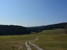
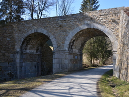
Starting from Summerau railway station, the route leads us south towards Freistadt. At Waldburg, you come across the Kronbach bridge, a double-arched stone bridge with a height of 12 metres. It is one of the most striking preserved structures of the horse-drawn railway.
TIP: Be sure to visit the three winged altars in the Waldburg parish church. Hardly anywhere else in Austria can you find three Gothic winged altars at once like in the church in Waldburg. The rather simple depiction of the figures still has a special charm for many viewers today. The figures appear very lifelike, which was probably much appreciated by the church people at the time of their creation (1517-1523). These works are artistically extremely valuable and represent a beautiful example of deeply felt popular piety.
The old town of Freistadt with its many narrow alleyways, an imposing town wall with preserved gates and defence towers and the beautiful town square are also definitely worth a detour. A visit to the Freistadt brewery commune teaches you the ancient art of brewing beer and is a welcome change from the efforts you have already made. In addition to the Hotel Hubertus, Freistadt also has numerous other accommodation options and places to stop for refreshments.
Through the Trölsberg forest to the Lest station building
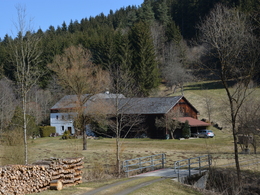
After the charming brewing town of Freistadt, the horse-drawn railway trail leads us to another highlight, namely the very well-preserved, two-storey, five-axle station building in Lest. Once here, the Gasthof Mader is the perfect place to stop off and recharge your batteries. The family-run business is known far and wide for its excellent cuisine, cosy rooms and hospitality.
TIP: Visit the world-famous Flügelalter in Kefermarkt via a circular hiking trail. Weinberg Castle, which is one of the most impressive buildings in the Mühlviertel region, is also worth a visit. In addition to a recommended visit to the local coffee house, there are also overnight accommodation options in Kefermarkt.
Path number: Rainbach - Lest
Starting place: 4261 Rainbach im Mühlkreis
Destination: 4291 Kefermarkt
duration: 5h 36m
length: 21,7 km
Altitude difference (uphill): 143m
Altitude difference (downhill): 312m
Lowest point: 509m
Highest point: 712m
difficulty: medium
condition: medium
panoramic view: Individual Views
Paths covering:
Asphalt, Gravel
Starting point: Start Summerau near Rainbach
Destination: Finish in Lest at Gasthof Mader near Kefermarkt
further information:
- culinary interesting
- Multi-day tour
- Possible accommodation
Details - hiking
- themed path
Accessibility / arrival
by car:
Highway Kufstein - Rosenheim - Salzburg - Linz - A7 direction Freistadt (Prague)
Vienna: Westautobahn - Linz - Unterweitersdorf - Mühlviertler Bundesstraße direction Freistadt - Rainbach
By train:
Summerauerbahn to Summerau station --> approx. 3km to Rainbach
General price information
free of charge
- Suitable for groups
- Suitable for schools
- Pets allowed
- Suitable for single travelers
- Suitable for families
- Suitable for friends
- Suitable for couples
- Suitable for children
- Spring
- Summer
- Autumn
- Early winter
Please get in touch for more information.
Lichtenauer Straße 11
4261 Rainbach im Mühlkreis
Phone +43 7949 6800
E-Mail office@pferdeeisenbahn.at
Web www.pferdeeisenbahn.at
Web www.muehlviertel-urlaub.at/wandern
http://www.pferdeeisenbahn.at
http://www.muehlviertel-urlaub.at/wandern
http://www.muehlviertel-urlaub.at/wandern


